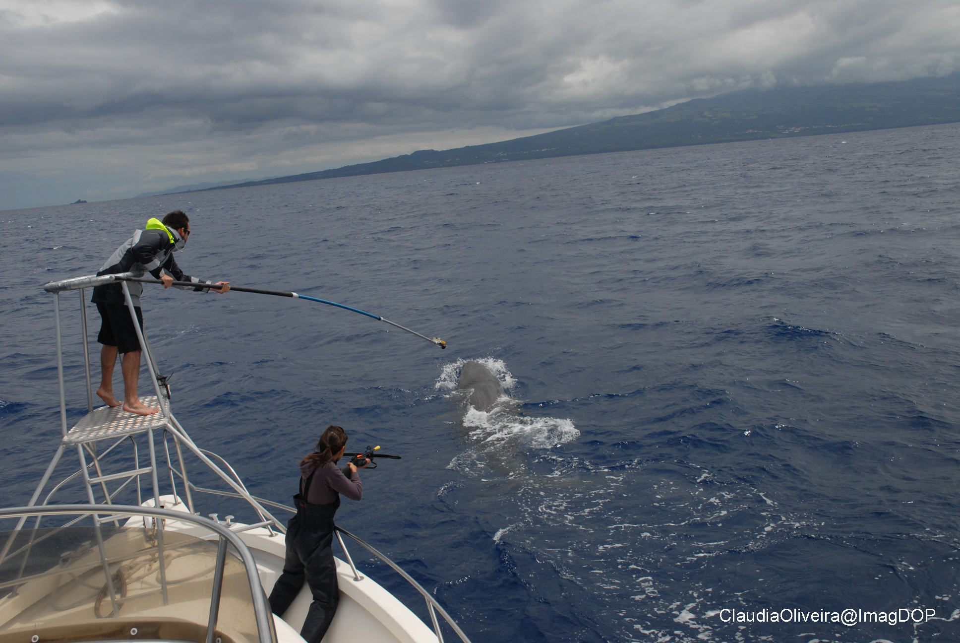
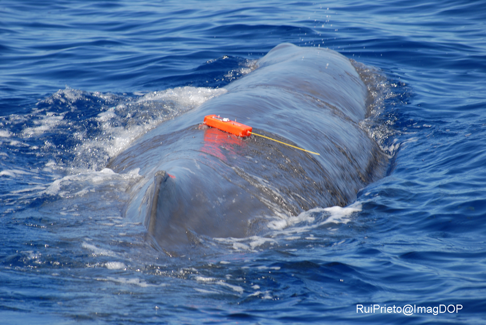
The Science

Spermwhale tagging
Spermwhale with tag

Cetacean Tracking

Apex predators are key components of the pelagic ecosystem and are associated with critical ecosystem services: they structure marine food webs and contribute to nutrient dynamics via the carbon pump. Yet, marine top predators can be especially vulnerable to changes in marine habitats. Understanding key physical and biological oceanographic processes that drive distribution and foraging activity in top predators is critical to predict how top predators will respond to natural and human-related environmental changes and disturbance and how this, in turn, affects the structure and dynamics of marine ecosystems.

Phase II of the REP-15 exercise will contribute towards these primary goals:

  1. characterize physical and biological oceanographic processes driving foraging behavior of pelagic predators (cetaceans, sharks, tunas, sea turtles, seabirds); 
  2. assess feasibility of different imaging sensors mounted on UAVs and AUVs to detect pelagic predators and obtain biometric and bioenergetic data; and
  3. investigate coupling between surface and deep-ocean processes.
Onshelf substrate nature interpreted from backscatter mosaics, bathymetric texture (Faial and Western Pico) and from seismic sub-bottom profiles (North, South and East of Pico island).

Habitat Mapping

During Phase I of the REP exercise, our primary scientific goal is to produce detailed underwater habitat maps for Pico island south shore, from 0 to 40 m. These detailed habitat maps will include high resolution bathymetry (depth, relief , substrate type and possibly dominant biotopes (sand, bare rock, dominant algal cover ect.). Water column biological and physical parameters will also be concurrently acquired by the fleet of AUVs, equipped with a suit of hi-tech acoustic, optical and imaging sensors. UAVs fitted with hyperspectral cameras will map the coast line and shallow areas down to 10 m, where it’s not safe to operate AUVs. Data from both aerial and underwater sensors shall be latter integrated to produce seamless high resolution habitat maps to support conservation and management decisions and the design of marine protected areas.

Figure on the left: Onshelf substrate nature interpreted from backscatter mosaics, bathymetric texture (Faial and Western Pico) and from seismic sub-bottom profiles (North, South and East of Pico island).

Mata Chacón, D., Sanz Alonso, J.L., Gonçalves, J.M.S., Monteiro, P., Bentes, L., McGrath, F., Henriques, V., Freitas, R., Amorim, P., Tempera, F., Fossecave, P., Alonso, C., Galparsoro, I., Vasquez, M., Populus, J. (2013). Report on collation of historic maps. Bathymetry, substrate and habitats – MeshAtlantic Report. Spanish Institute of Oceanography. 98 pp.
The CTD/LADCP system that will be used during PhaseII-REP15 and example of vertical profiles of temperature, salinity and turbidity (nephelometry) collected in deep water with this system.

Environmental Characterization

The main objectives of the Instituto Hidrografico (IH) in Phase II of REP-15 will be the characterization of the environmental conditions affecting the geographical area(s) of interest, focusing on the dominant physical process, and the test of strategies to combine into a data assimilation model both data collected onboard a vessel and data collected by AUV systems operating in the area. Our strategy to attain this objective will integrate two main components. Profiles of currents, temperature, salinity, turbidity and chlorophyll concentration will be collected in the area of interest, between the surface and the bottom, using a CTD probe equipped with a Lowered ADCP and the vessel mounted ADCP. A numerical model with assimilation of the CTD profiles will be used to (a) provide forecasts of the evolution of the environmental conditions during the survey and (b) build a synoptic image of those conditions from the complete data set collected in the area of interest.  
 
Figure on the left: the CTD/LADCP system that will be used during PhaseII-REP15 and example of vertical profiles of temperature, salinity and turbidity (nephelometry) collected in deep water with this system.
Espalamaca vent field: A. Location and bathymetry (by F. Tempera and I. Sebastião)
Espalamaca vent field: B. Vent field and detail imagery (by J. Fontes)

Mapping of shallow vent fields

The Espalamaca vent field is an area of underwater volcanic carbon dioxide (CO2) degasification located in the Faial-Pico channel off the Espalamaca headland (Faial Island, Azores, NE Atlantic). Because of the high concentrations of CO2 in the vent field, it mimics the input of CO2 into the oceans due to anthropogenic activities, and thus is currently used as natural laboratory for conducting ocean acidification (OA) experiments, called OceanA-Lab (financed by Direcção Regional para a Ciência e a Tecnologia M2.1.2/F/021/2011). The laboratory consists of a platform of modular structures which allows the attachment and assemblage of a range of instruments and experiments, providing the opportunity to develop experimental and observational studies under naturally varying pCO2/pH conditions (http://oceana-lab.wix.com/oceana-lab, see figures on left).

Research conducted to date, has contributed to the delimitation of the main venting area, the long-term monitoring (2.5 years) of the geochemical properties (e.g. gaseous composition, temperature, carbonate chemistry, elemental composition),  and the characterization of natural occurring fauna through video and photoquadrats. Nevertheless, the depth and operational constraints of scuba diving activities have, so far, hindered the delineation of the exact extent of the vent field. Tools to be used during REP15 will provide the opportunity to get high resolution maps which will benefit ongoing research providing the possibility to pinpoint, identify and monitor specific vent structures in the area. Specific objectives are:

  1. Underwater mapping of main venting area to collect bathymetry with highest resolution possible and with overlay of imagery mosaic (ideally in 3D);
  2.  Hyper-spectral survey of main venting area and surroundings to detect different geomorphological structures;
  3.  AUV transects surrounding the main venting areas, to identify the presence and location of vent structures and activity in areas and depths that have, so far, been out of reach for ongoing research and scientific divers. Transects may likely provide imagery of biota that have not yet been observed in this vent area
Dronespec design (Prof. Fred Sigernes). Spectral resolution about 4 nm and spectral range is 400-700 nm.

Hyperspectral imaging using UAV's

The hyperspectral high resolution miniature imaging spectrometer, Dronespec, owned by Norut and made by Prof. Fred Sigernes at UNIS, has been integrated into an NTNU X8 fixed wing UAV (Unmanned Aerial Vehicle) and the Neptus command/control system. The imager will be used to detect chlorophyll-A and phytoplankton as well as other suspended matter. Chlorophyl-A concentration is closely linked to the primary production in the ocean while other suspended matter or algea concentration can be quantitatively determined given that the inherent optical properties are known. A qualitative measurement using multivariable clustering and/or thresholding techniques can be used to detect other substances. The CAO-DISORT and bio optical models developed by the Light and Life Laboratory at Stevens Institute of Technology will be used for retrievals as well as the SeaDas software from NASA.

Figure on the left: Dronespec design (Prof. Fred Sigernes). Spectral resolution about 4 nm and spectral range is 400-700 nm.